
|
Administration Office
1702 Noble Street
Suite 103
Anniston, AL 36201
Phone: 256-241-2800
[email protected]
Created by the legislature December 18, 1832, from the land ceded by the Treaty of Cusseta, executed March 24, 1832. Calhoun County lost part of its original territory by the formation of Cleburne, December 6, 1866, and Etowah County December 7, 1866. Its area is 630 square miles or 403,200 acres.
The vast majority of this information was compiled in 1921 by Thomas McAdory Owen, LL.D. Although old, history does not change and is fun reading. It is our hopes to update these pages with additional information as it becomes available, either through our own research or from the citizens of this great County.
Additional Information on various cities, locations in Calhoun County, and other County information is located below. If you have additional information, please contact us via email at [email protected].
Reference information can be found in each section or at the bottom of this page.
Click on the links below to jump to each section.
General County History
Physical Description
Indian History
City History:
Alexandria
Anniston
Blue Mountain
Hobson City
Jacksonville
Oxford
Piedmont
Weaver
Camp McClellan
Camp McClellan Library
Chinnaby's Fort
Choccolocco Creek
Choccolocco Valley
Coldwater Mountain
Jacksonville or Choccolocco Mountains
Jacksonville State University
Noble Institute
Probate Judges
First Public Library
Battle of Tallaseehatchee
Reference Information
Calhoun County History
Created by the legislature December 18, 1832, from the land ceded by the Treaty of Cusseta, executed March 24, 1832. It lost part of its original territory by the formation of Cleburne, December 6, 1866, and Etowah County December 7, 1866. Its area is 630 square miles or 403,200 acres.
It was established as Benton County, in honor of Col. Thomas Hart Benton, senator from Missouri. Among other things in his public career commending him to Alabama was his service in the War of 1813-14. As a field officer he served in Alabama, being for a time in command of Fort Montgomery, Baldwin County. His later political course, however, rendered him unpopular in the State, and January 29, 1858, the name of the county was changed to Calhoun, in honor of the great States Rights leader of South Carolina.
The same legislature, January 12, 1833, named Samuel J. Bradford, Moses Benson, Christopher A. Green, John Mattox and Matther H. Haustin [sic] commissioners, who were empowered to locate the county seat, at or near the center of the county if practicable, or, if not, at the most eligible point, not exceeding six miles from the center. The place selected was given the name Jacksonville, in grateful appreciation of the services of Gen. Andrew Jackson to the State, lands were purchased, and a court house and jail erected.
The legislature, January 9, 1833, elected Christopher Green judge of the county court over Willis Franklin. The county was further organized by an election, held the first Monday in March, 1833, at which James Brown was chosen sheriff, James Crow clerk of the circuit court, and Wm J. Arnold clerk of the county court.
The growth of Anniston, the location of railroads, and the previous reduction of the county boundaries by the creation of Cleburne and Etowah Counties, changed conditions and brought about an agitation for the relocation of the county seat. In response to the demand the legislature, February 16, 1895, authorized an election to be held to determine whether it should remain at Jacksonville, or be removed to Anniston. The advocates of removal lost, but they again appealed to the legislature. Another election was ordered by an act of November 30, 1898, later amended February 1, 1899, in which Jacksonville lost. The commissioners exofficio under this act were the clerk of the City Court of Anniston, the mayor of Jacksonville, and chancellor of the Northeastern Chancery Division. The people of Anniston complied with the terms of the act, a suitable site was secured, and the officers and records were removed.
Additional information on Calhoun County can be found on the Encyclopedia of Alabama website. This site uses much of the same information gathered from the History of Alabama and Dictionary of Alabama Biography that we use here.
Top
Location and Physical Description
Calhoun County lies in the northeastern section of the state. On the north lies Cherokee and Etowah, on the east Cleburne, on the south Talladega and on the west Etowah, St. Clair and Talladega. The Coosa River in a southwesterly course is its dividing line with St Clair County. Practically the whole county area is within the Coosa Valley region, with the exception of a narrow strip along its western boundary, which latter is an extension of the Appalachian Mountain system. The topography is generally rolling to hilly or mountainous, with elevations ranging from about 600 feet in the valleys proper, to over 2,000 feet upon the peeks of Choccolocco and Cold Water mountains. These mountains form the watershed, and largely determine the direction of the streams. The Choccolocco, Nancy, Terrapin, Ohatchie [sic], Tallahatchie [sic], Cane, Cold Water and Eastoboga [sic] creeks largely comprise the drainage of the county, which finds an outlet through the Coosa and Alabama rivers to the Gulf. The soils are derived largely from the underlying geological formations, and are derived directly or indirectly from limestone, sandstone and shale. There are 18 distinct types shown in the survey. These include stony loam, shale loam, clay loam, and fine sandy loam. The varied geological features of the county make possible its great resources. It has deposits of the Knox dolomite, manganese ore, china clays, galena, barite, quarries of limestone and Weisner sandstone, beds of slate, and chert for road making. The Piedmont Springs, of chalybeate water, are located in the county. A small area is embraced in the Warrior coal fields. Its forest growth consists principally of longleaf and shortleaf pine, post oak, red oak, blackjack, beech, poplar, sweet gum, walnut, hickory, elm and ash. The climate of the county is equable. Its mean annual temperature ranges from 44 degrees F. in winter to 77 degrees F. in summer. The average dates of the first and last killing frosts are October 20 and April 2. The mean annual precipitation is slightly less than 50 inches, and is evenly distributed throughout the growing season. The climate, the soils and its varied topography afford a wide range for diversified agriculture, and it is well adapted to stock raising.
Top
Indian History
The county lies within the domain of the Creek Indians. It was traversed by De Soto in 1540 on his way to Cosa. Three miles southwest of Jacksonville on Tallasseehatchee Creek was the town of Tallasseehatchee, where General Coffee defeated the Creeks, November 3, 1813. About 12 miles south of Jacksonville on the north side of Big Shoal Creek, in the vicinity of Wolfskull Creek on the south was Chinnaby’s Fort, and some three miles below it, on the same side of the creek was an Indian village, whose name has not been preserved. Scattered along the Coosa River are many evidences of very aboriginal occupancy. Near Choccolocco Creek, three miles southwest of Oxford on the Carver place is a large isolated mound. The site has not been identified. In the southwestern corner of the county, on Coosa River at the influx of Cane Creek is a large village site, where chipped implements and pottery are quite numerous. This is the location of Tali of De Soto’s time. Several sites are noted above this point, but none are associated with any places of historic times.
Top
ANNISTON
County seat of Calhoun county; on the main lines of the Southern Railway, the Seaboard Air Line Railway, and the Louisville & Nashville Railroad. It is situated in an amphitheater of the Blue Ridge Mountains, in the southern part of the country, in secs. 5 and 6, and 7 and 8, T. 16, R. 8; 63 miles northeast of Birmingham, 148 miles north of Montgomery, 104 miles west of Atlanta, and 142 miles south of Chattanooga, Tenn. Altitude: 800 feet. Average temperature: 80 degrees in summer and 40 degrees in winter. Population: 1880 – 942; 1890 – 9,998; 1900 – 9,695; 1910 – 12,794; 1915 – 20,000.
The town was first known as Woodstock. It was incorporated as Anniston in 1873, under the general laws, and by the legislature, February 4, 1879. The town was created as a separate school district by act of February 3, 1883. The charter was amended and greatly amplified by act of February 23, 1889. The Woodstock company threw the town open to outsiders in 1883, and its growth to 1890 was phenomenal. The corporate limits comprise a 3-mile circle, whose center is at the crossing of Noble Avenue, and 17th Street. It has waterworks, built in 1881; fire department, consisting of 3 stations, each with a motor truck; privately owned electric light and power plant, and gas plant; city hall; jail; 30 mile of sanitary sewerage; 2 miles of bithulitic and 35 miles of macadamized streets; cement sidewalks; and 15 miles of electric street railway.
Churches: Anniston has been called “the Brooklyn of the South,” or “the City of Churches.” In 1881 the Episcopalians established a mission under Rev. W. Carnahan, and soon afterward erected a $35,000 building. They now have two churches – Grace Church, and St. Michael and All Angels. In 1883, the Methodist Episcopal Church, South, under Rev. T. H. Davenport, established the First Methodist Church. Later the McCoy Memorial, Oxanna, St. Pauls, and Wesley Chapel were built. In the same year the Baptists built the Parker Memorial, The First Baptist Church, Blue Mountain, Glen Addie and West End churches. In 1884, the Presbyterians established their first church organization in the town. They now have the First, Second, and Glen Addie Churches. Besides these, there are Northern Methodist, Congregational, Cumberland Presbyterian, Church of Christ, Catholic, Jewish, 7 Negro Baptist, 8 Negro Methodist, and 2 Negro Presbyterian Churches. Anniston has 18 small parks and playgrounds distributed over the city; Oxford Lake park; the country club and golf links.
In 1862, the land on which Anniston now stands was owned by D. P. Gunnells of Oxford, who sold it to the Oxford Furnace Company. In 1872, Samuel Noble and Daniel Tyler bought the ruins of old Oxford Furnace, and rebuilt it, and organized the Woodstock Furnace Co., which was one of the few southern industries that survived the financial panic of 1873. Its fires were never banked, and its product always found a market. Samuel Noble, to whom Anniston has erected a fitting memorial, laid out its broad streets, conserving the parks, providing sewerage and waterworks, planting its splendid avenues of trees and making a model city. In 1883, the demand from outside was so insistent, that the manufacturing city was formally opened to the public. Henry W. Grady the gifted Georgia editor, of Atlanta, presided for the company. The county seat was removed to Anniston in 1895.
The earliest settlers of this region were the Gunnells and Edmondson families. The most notable residents were Samuel, James, John and William Noble, and Daniel, Alfred L. and E. L. Tyler. General Daniel Tyler died in New York City, 1882, but his body was brought to Hillside Cemetery, Anniston. He was the grandfather of Mrs. Theodore Roosevelt, sr. (Edith Carew).
References. – Acts, 1878-79, pp. 353-359; 1882-83, pp. 335-337, 461; 1888-89, pp. 601-624; Armes, Story of coal and from in Alabama (1910), pp. 179, 180-185, 310 et seq.; Northern Alabama (1888), pp. 470-477; Anniston Chamber of Commerce, Folders and pamphlets.
Top
ALEXANDRIA
Post office and station, in the central part of Calhoun County, secs. 34 and 35, T. 14, R. 7, E., on the Louisville & Nashville Railroad, 10 miles northwest of Anniston, and 25 miles southeast of Gadsden. It was first called Coffeeville, in honor of Gen. Coffee, who fought a battle with the Indians in 1813, 2 1/2 miles west of Alexandria. Later it was changed to the present name.
Altitude: 555 feet. Population: Alexandria Precinct, 1870 – 1,689; 1880 – 121; 1888 – 100; 1910 – 90; Alexandra Precinct, including the town, 1910 – 2219.
The locality was settled about 1834, or earlier. Among its prominent settlers and citizens have been Dr. Atkinson Pelham, Dr. John H. Vandiver, Col. John M. Crook, S. D. McClelen, Elisha McClelen, Robert A. McMillan, Daniel Crow, Jacob R. Green, Lewis D. Jones, Seaborn Whatley, Floyd Bush, Daniel Bush, Rev. J. J. D. Renfroe, and Frank Woodruff. “The Gallant Pelham,” son of Dr. Pelham, was born and reared near Alexandria.
References. – Brewer, Alabama (1872); Northern Alabama (1888), p. 112; Polk’s Alabama gazeteer, 1888-9, p. 71; Alabama Official and Statistical Register, 1915.
Top
CAMP McCLELLAN
United States Army Camp, located 5 miles north of Anniston which was founded in 1917. Upon the agreement of the citizens of Anniston to furnish land, water mains, electric lights, etc., the government of the United States agreed to locate a military camp at that point, where soldiers were to be trained for participation in World War I.
The 29th Division consisting of the headquarters troop; the military police; two brigades of infantry; three regiments of artillery; sanitary trains; French motor battery; field signal battalion; engineer regiment; engineer trains; ammunition and supply trains were trained at Camp McClellan before embarking in May for France.
A remount station, No. 309, was maintained, and a base hospital was constructed with a capacity of 1,256 beds. The Southern and Louisville and Nashville railways had sidings which led into the camp.
The Red Cross, Knights of Columbus, Salvation Army, War Camp Community service and Hostess Houses gave places for amusement and entertainment.
The American Library Association maintained a library known as Camp McClellan Library.
Camp McClellan was renamed to Fort McClellan in 1929
and was the training ground for half a million soldiers during World War II.
References. – Manuscripts in the files of Alabama Department of Archives and History.
Top
CAMP McCLELLAN LIBRARY
Branch of the American Library Association maintained at Camp McClellan, Anniston, for the purpose of supplying officers and enlisted men with books and magazines.
The camp library was opened by Mr. Carl H. Milam, on October 30, 1917, in a mess shack. At that time there were 2,000 books in the collection furnished by the people of Minneapolis and Chicago. Shortly afterward branches were opened in the “Y’s” and “K.C.” building.
Mr. Milam, after selecting the site, which was one of the best in the city, let the contract for the building which on February 9, 1918, was opened to soldiers. Its dimensions were 40 by 93 feet, and was furnished with regulation library tables and comfortable chairs. The men were allowed to smoke and were made to feel at home.
The collection of books grew shortly from 2,000 to 40,000 volumes. The greater number were furnished by the people of Birmingham and of Wisconsin and Illinois. The American Library Association purchased about 7,000 books for the library. Small collections were placed about camp in such a manner that they were accessible to the men at all times. All “Y” huts, the “K. C.” building and “J. W. B.” hut were provided, and books were placed in each ward in the Base Hospital.
Many magazines were distributed by the Library. During November, 1918, the library received a call for books to be sent overseas. About 8,000 volumes were shipped. During the closing period of March and April, 1919, 23,000 books were shipped to other camps, and when the library disbanded a good collection was given to the War Camp Community service, so that ex-service and service men might have good reading matter. The library was officially closed April 19, 1919.
Top
BLUE MOUNTAIN
Post office and station at the crossing of the Louisville & Nashville Railroad and the Southern Railway; in the northern suburbs of Anniston, 2 miles from the center of the city. It is one of the cotton-mill and iron-mining sections of the city of Anniston. Population: 1910-528. The locality was settled by the Hudgins family in the late thirties and for years was the terminus of the Selma, Rome and Dalton Railroad, being the shipping station for the Oxford furnace. During the War,
the Confederate Government operated both the railroad and the furnace, the iron being shipped to Selma to make “Ironclads” for the Confederacy. The town was burned in 1864.
References. – Armes, Story of coal and iron in Alabama (1910), pp. 180-182, 206.
Top
CHINNABY’S FORT
An old Creek Indian defense in Calhoun County. There is a difference of opinion as to its exact location. Drake states that in 1813 a friendly Creek chief named Chinnaby had a kind of fort at Ten Islands on the Coosa River, and to which his name was given. The map accompanying the Eighteenth Annual Report of the Bureau of American Ethnology, however, places it at a point on the north side of Choccolocco Creek, and near the influx of the Wolfskull Creek.
References. – Gatschet, in Alabama History Commission, Report (1901), vol. 1, p. 395; Drake, Book of Indians (1848), p. 55; Bureau of American Ethnology, Eighteenth Annual Report (1899); pt. 2, map 1; Handbook of American Indians (1907), vol. 1, p. 272.
Top
CHOCCOLOCCO CREEK
One of the larger tributaries of the Coosa River (q. v.). It rises in the northeastern corner of Calhoun County and flows southwestwardly to Jenifer, thence westwardly to its confluence with the Coosa, near the southwest corner of the county. The length of the stream has not been determined. Its low-water width varies from 100 to 250 feet, and its depth from a few feet on shoals to 10 or 15 feet in pools. Its minimum discharge in 1908 was 109 cubic feet per second; its maximum, 5,270 cubic feet. It is not classed as a navigable stream, and no improvements by the U.S. Government have been undertaken. The Choccolocco lies wholly within the great Coosa Valley (q. v.), and the topographical and geological features of its drainage area are practically the same as those of the Coosa Valley.
See Choccolocco Valley.
Reference. – Manuscript data in the Alabama State Department of Archives and History.
Top
CHOCCOLOCCO VALLEY
A valley of small area lying between the Jacksonville or Choccolocco Mountains on the northwest and the hilly country of the Talladega slates on the southeast, in Talladega County. It is bounded on the northwest by the Terrapin or Ladiga Mountains, and is nearly 30 miles long and about 5 miles wide at its broadest part, making its area approximately 75 square miles. The soils of the valley are fertile, and almost its whole area is in cultivation. In the northeastern end, where its surface is somewhat rugged, there are still virgin forests of pine and hardwood. In the upper strata of some of these timbered knolls and ridges, there are valuable limonite banks. After the Indian land cessions, it was rapidly settled by a fine body of immigrants. They were largely from North Carolina and South Carolina.
Reference. – McCalley, Valley regions of Alabama, Pt. 2, Coosa Valley (Geol. Survey of Ala., Special report 9, 1897), p. 21.
Top
COLDWATER MOUNTAIN
The intersection of two great faulted unsymmetrical anticlinals with northeast-southwest and northwest-southeast trends, respectively. Its structure is complicated by smaller anticlinals, faults, etc. It is situated in Calhoun County and is really the broken-up, southwest end of the Jacksonville or Choccolocco Mountains, from which it is separated by the irregular, narrow, unsymmetrical, synclinal valley between Oxford and Anniston. Its highest peaks are more than 2,000 feet above sea level. At the southwestern end of the mountain there are many fine springs of clear water gushing out from under a knoll of massive conglomerates. These springs supply the city of Anniston with water. On the top of the mountain are several bald spots of perfectly naked, flat rocks, which are doubtless the tops of two intersecting waves. Near the northeast extremity of the mountain there are numerous large deposits of limonite, some of which have been worked extensively. Bauxite also occurs in the same vicinity.
References. – McCalley, Valley regions of Alabama, Pt. 2, Coosa Valley (Geol. Survey of Ala., Special report 9, 1897), pp. 19, 676-679; U.S. Dept. of Agriculture, Bureau of Soil Surveys, Soil survey of Calhoun County (1910), pp. 5-6.
Top
HOBSON CITY
Hobson City is located in Calhoun County just south of the city of Anniston. At its founding in 1899, Hobson City was the only municipality governed entirely by African Americans in Alabama. It was named for naval hero Richmond Pearson Hobson of the Spanish-American War. In 2010, the Alabama Historical Commission declared the town one of Alabama's "Places in Peril.
Top
JACKSONVILLE
Post office and incorporated town in the east-central part of Calhoun County, and on the Southern Railway, about 12 miles north of Anniston, about 50 miles southwest of Rome, Ga., and about 20 miles southeast of Gadsden. Altitude: 720 feet. Population: 1870 – 958; 1888 – 2,000; 1890 – 1,237;
1900 – 1,176; 1910 – 2,231. It was incorporated in 1836. Its corporate limits were enlarged to their present dimensions in 1860, and in 1907 the town adopted the general municipal code. It has a city hall and a jail, erected in 1906, a volunteer fire department, and several miles of cherted streets. There are parks and playgrounds covering several blocks. The city installed a waterworks system in 1868, which was later sold to private persons. It also has a privately owned electric light plant. The city tax rate is three-fourths of 1 per cent, and its bonded indebtedness $32,000 - $10,000 for waterworks, $10,000 for State normal college, and $12,000 for city high school. The First National is the only bank. The Jacksonville Record, a Democratic weekly established in 1906, and the Bulletin of the State normal college, a quarterly established in 1905, are published there. Its industries are the Profile Cotton Mills, capitalized at $1,000,000 and spinning thread only, cotton ginneries, cotton warehouses, fertilizer plant, cottonseed oil mills, heading mills, 2 flouring mills, grain mills, waterworks plant, electric light plant, and iron ore, kaolin, and lead mines in the vicinity. There are also marble and limestone quarries nearby. The Jacksonville State Normal College, established in 1884, is located in the town.
In 1833 Jacksonville built the county courthouse in the center of a large square. When the county seat was removed to Anniston in 1895, the Jacksonville people placed a handsome Confederate monument in the center of one square.
Among the early settlers of the locality, were the Forney, Foster, Crook, Stevenson, Abernathy, Gardner, Pelham, Walker, and Ellis families.
References. – Brewer, Alabama (1872), pp. 152 et seq.; Northern Alabama (1888), p. 111; Polk’s Alabama gazetteer, 1888-9, p. 440; Alabama Official and Statistical Register, 1915
Top
JACKSONVILLE OR CHOCCOLOCCO MOUNTAINS
A high range of mountains extending from Piedmont to Oxford, in Calhoun County, a distance of 25 miles. Their highest peaks range from 1,800 to 2,000 feet above sea level. These mountains are separated from the Coldwater Mountain to the southwest, by the narrow, faulted valley between Oxford and Anniston, and from the Terrapin Mountains, to the northeast, by the similar valley between Piedmont and White Plains. In the top strata of the mountains there are many deposits of limonite.
Reference. – McCalley, Valley regions of Alabama, Pt. 2, Coosa Valley (Geol. Survey of Ala., special report 9, 1897), pp. 18-19, 679.
Top
JACKSONVILLE STATE NORMAL SCHOOL
A “Class A” normal school “established by the State of Alabama to prepare teachers for its public schools.” It was chartered February 22, 1883, and as appears by the act, was “permanently established in the Calhoun college building at Jacksonville.” A board of directors, consisting of S. K. McSpadden, John M. Caldwell, James Crook, W. P. Howell, Wm. M. Hames, D. A. Aderholt, H. L. Stevenson, W. J. Alexander, J. Y. Nisbet, L. W. Grant and John D. Hammond, and the superintendent of education, was named in the act. Mr. Hames was subsequently chosen president of the board, and John M. Caldwell, secretary.
The board was directed to organize the school “upon the most approved plan,” and authority was given to establish “a public school or other school” in connection with the institution. The faculty was required “to establish a course of instruction with special reference to educating teachers in the theory and practice of teaching.” Students were to be admitted from any part of the State, and “shall receive instructions free of charge for tuition, upon signing a written obligation to teach at least two years in the public schools of Alabama.” Graduates were empowered to teach in the public schools of the State without further examination. The sum of $2,500 annually was appropriated “out of the general educational revenue apportioned to the whites.” While the charter contained many other general provisions the foregoing illustrate the attitude of the legislature at the beginning of this form of educational enterprise.
The school opened in the fall of 1883, with James G. Ryals, Jr., as president. The first class was graduated in 1886. Through the assistance of Dr. J. L. M. Curry, $300 annually was granted by the Peabody Education Fund, which sum was later substantially increased. In 1899 an experimental garden and field was established in connection with the study of botany and physiography. In 1903 the trustees arranged a system of scholarships, whereby one person from every county in the State might receive tuition free of charge. In 1910 Mrs. Fannie Atkins made a donation to the school of 123 acres of land and the dwelling thereon in memory of her husband, David Atkins.
Legislative History. – The original charter provided that the directors should hold office at their own pleasure. This was changed by act of February 15, 1897, the governor was added to the board, and upon him was conferred the power of appointment. The legislature, December 9, 1900, ratified and confirmed the action of the county commissioners in donating to the State for the school, the old courthouse and the lot on which it was located, so long as “used by said school for school purposes,” but a later act of August 2, 1907, empowered the trustees to sell the old building and the grounds for the use of the institution. On September 9, 1903, the legislature increased the appropriation to $10,000. A still further appropriation of $60,000 was generously made, April 20, 1911, to meet “a balance due for permanent improvements heretofore made [for] equipments and buildings for said school, and to aid in further erection of necessary buildings for the same; and for improving and extending the grounds thereof.”
Library. – The school was one of the first of the educational institutions in the State to appreciate the value of trained librarianship. In 1908 Miss Susan Lancaster, a graduate librarian, was engaged. The library at once took its place as a laboratory of real service to both faculty and students, standard rules were substituted for haphazard use, a love of reading was stimulated, and courses offered in library methods and in the use of books. The library uses the Dewey decimal classification, and is carefully catalogued. It is kept open every day except Sunday. It numbers about 2,500 volumes.
General Details. – The courses of study, organization of departments and general ideals conform to the requirements prescribed by the State Normal School Board, established in 1911. (For details see Normal Schools.) Public lecture courses are provided during the sessions. Three literary societies are organized among the students: the “Calhoun” and the “Morgan” for men, and the “Sidney Lanier” for women. Active branches of the Y. M. C. A. and the Y. W. C. A. are maintained. A summer school of 12 full weeks if offered as a permanent part of the school plan. Physical culture courses are required, modeled upon the Ling-Swedish system.
The department of rural school work is designed to meet the growing demand for teachers with special preparation for rural work. “The course includes such subjects as the organization and management of the rural school, grading, daily program, physical environment, rural school methods and rural sociology. Opportunity is given the students to observe work of the rural schools near Jacksonville. Two of these schools are used as model and practice schools, one at Merrillton and one at Cedar Springs. The effort is made to use the county rural schools of Calhoun as training schools for the teachers of the State enrolled here. A lyceum course is maintained for them, school associations encouraged, industrial work stressed, county supervision had, better teachers, fewer schools, longer terms, and better roads advocated. The efforts put forth by the school in this work are discussed with the pupil teachers. The vital problems of the rural school which are met and dealt with furnish valuable lessons to them. A county commencement and a fair demonstrate the results obtained and furnish a strong incentive to get the work started in their home counties.” – Catalogue, 1916-17.
On September 20, 1916, its report to the State superintendent of education showed buildings and site valued at $80,000; equipment, $12,000; 15 teachers; 436 pupils, of which 173 were in the model school, and 261, in the normal work; and State appropriation of $20,000.
Presidents. – James G Ryals, 1883-1885; J. Harris Chappell, 1885-1886; Charles B. Gibson, 1886-1892; Jacob Forney, 1893-1899; Clarence Wm. Daugette, 1899-.
References. - Acts, 1882-83, pp. 520-522; 1896-97 pp. 1033-1035; 1900-01, pp. 131-132; General Acts, 1903, pp. 238-239; 1907, pp. 544-545; 1911, p. 586; Clark. History of education in Alabama (1889), p. 256; Weeks, History of public school education in Alabama (U. S. Bureau of Education, Bulletin 12, 1915); and Publications supra.
Additional information, including current history, can be found on the Encyclopedia of Alabama web site.
Top
NOBLE INSTITUTE
Private school for the education of girls, located at Anniston. This institution was established in 1886 by the late Samuel Noble as a day school for girls. In accordance with his plans, his widow and children erected an adjoining building in 1889 which is used as a dormitory for boarding pupils. These buildings are of stone and brick, and equipped throughout with steam heat, and are well lighted and ventilated. “The aim of the school is to give a thorough preparation for college, and to offer a course of instruction to students who do not intend to enter college.” Primary and collegiate preparatory courses are offered.
The school has an excellent library and a good corps of instructors. At different times the following scholarships have been awarded: Wilmer, Spaulding, Tyler, and Grace Church.
Presidents: Elinor Otey Anderson, 1900-1902; Miss Matilda Gray and Ethal Moore, co-presidents since 1902.
References. – Catalogues 1899-1910; Circular of Information issued in 1907; circular of illustration, 1907.
Top
OXFORD
Post office and incorporated town, on the Southern Railway and the Louisville & Nashville Railroad, in the southern part of Calhoun County, on Big Shoal Creek, 3 miles south of Anniston, and 22 miles northeast of Talladega. Altitude: 640 feet. Population: 1870 – 1,147; 1880 – 780; 1890 – 1,473; 1900 – 1,372; 1910 – 1,090. It is incorporated under the municipal code of 1907. It rents all its municipal buildings except the jail and fire department buildings. It has privately owned gas and electric light plants, municipally owned waterworks, 8 miles sanitary sewerage, paved sidewalks laid in 1912 and 1913 at a cost of $6,000, and a volunteer fire department. Its tax rate is 5 mills, and its bonded indebtedness, $22,000, maturing in 20 years - $10,000 for waterworks, and $12,000 for sewerage. There is an electric street car system between Oxford and Anniston, and to Oxford Lake, the site of the plant of the Alabama Power Co. The First National Bank is the only banking institution, and the Oxford Tribune, a weekly, its only newspaper. Its industries are a cottonseed oil mill, a linter ginnery, a fertilizer plant, a cotton ginnery, a firebrick plant, a cotton-cord and twine mill, a Farmer’s Alliance warehouse, and iron ore and coal mines in the vicinity. It is the location of the Calhoun County High School. There is a playground or park, occupying a large block in the city, and under the supervision of the school improvement association. Oxford Lark Park, owned by the Alabama Power Co., is convenient to the town.
The locality was known in pioneer days as “Lick-Skillet,” but for what reason no one now knows. It was settled by the Kelly, Snow, Gunnells, Dudley, and Don families. In 1868 John L. Dodson founded Oxford College there (q. v.).
References. - Armes, Story of coal and iron in Alabama (1910), pp. 179 et seq.; Brewer, Alabama (1872), p. 152; Northern Alabama (1888), p. 112; Polk’s Alabama gazetteer, 1888-9, p. 640; Alabama Official and Statistical Register, 1915.
Top
PIEDMONT
Post office and incorporated town, on the Southern Railway and the Seaboard Air Line Railway, in the northeast corner of Calhoun County, 13 miles northeast of Jacksonville and about 25 miles northeast of Anniston. Altitude: 705 feet. Population: 1880 – 381; 1890 – 711; 1900 – 1,745; 1910 – 2,226; 1916 – 3,000. Its banks are the First National and the Farmers & Merchants Bank (State). The Piedmont Journal, a Democratic weekly, established in 1907, is published there. Its industries are large cotton mills, 2 cotton ginneries, and a rim-binding factory. It was first called Cross Plains, from its situation on the edge of a plain and at the crossing of two important stagecoach roads. The name was changed to Piedmont about 1880. The first settlers were Neal Ferguson, Jacob F. Daily, Hampton Graham, Gilbert Craig, John W. Ledbetter, James Price, Dr. R. G. Teague and Dr. John B. Cowden.
References. – Polk’s Alabama gazetteer, 1888-9, p. 291; Lippincott’s gazetteer, 1913, p. 1444; Alabama Official and Statistical Register, 1915.
Top
PROBATE JUDGES OF CALHOUN COUNTY
Judge Emmett Farrow Crook 1886 - 1912
Born in 1851 to Colonel John Martin Crook and his second wife, Narmesia Woodruff Crook, Emmett Farrow Crook worked in the mercantile business and farmed as a young man in Alexandria, Alabama. He married Sallie (Sara) Walker in 1872. In 1886, Emmett Farrow Crook was elected Probate Judge of Calhoun County, and was re-elected to that office for 26 years. Due to failing health, he had to resign his position in March 1912. He was a deacon at Parker Memorial Baptist Church for many years. He was also a Mason and an Elk. *This information was provided by Barbara Crook Vaden Sproull.
1912 - 1916: Probate records reflect that during this period three men signed court records; John M. Crook, as “Clerk of Probate Court”, Jos. J. Arnold, W.H. Cooper, and J. F. Rowan.
Judge Thomas W. Coleman 1916 - 1940
Thomas Wilkes Coleman, Jr. was born December 19, 1868 to Thomas Wilkes Coleman and Frances J. (Wilson) Coleman. He married Carrie Arnold in 1891, in Anniston. He was a lawyer, and began his practice in Anniston, Alabama in 1889. He was a member of the legislature from 1896 - 97; attorney for the City of Anniston from 1897 - 99; Judge of the City Court of Anniston from 1901 - 1916. Judge Coleman served as Probate Judge of Calhoun County from 1916 - 1940. *This information can be found in History of Alabama and Dictionary of Alabama Biography, Volume 3.
Judge S. Elbert Boozer 1940 - 1947
Judge S. Elbert Boozer was elected, but took office early by appointment, due to the death of Judge Thomas W. Coleman.
Judge Boozer was one of Anniston’s leading businessmen, and a two-time gubernatorial candidate. He stated in a profile published August 8, 1971, at the age of 76, that he “went in as Probate Judge here with the special purpose of running for Governor.” He ran for Governor in 1946, finishing third in a seven-man race, and again in 1950.
Judge G. Clyde Brittain 1947 - 1975
Judge G. Clyde Brittain served as County Treasurer, prior to being elected Probate Judge of Calhoun County, according to county archives. He was a graduate of Auburn University.
Judge Arthur C. Murray 1975 - 2007
Judge Arthur C. Murray, formerly a businessman, was appointed by Governor George C. Wallace as Probate Judge in 1975. Judge Murray is among only a few who served as Probate Judge for over thirty years. He continues to serve, when appointed by the Chief Justice of the Supreme Court, as Special Probate Judge, in cases where a Probate Judge must recuse. Upon his retirement, Judge Murray was recognized by the Probate Judges’ Association for having the most “up-to-date” records of any Probate Office in the State of Alabama.
Top
FIRST PUBLIC LIBRARY IN CALHOUN COUNTY
Alexandria Women built the Margaret Woodruff Library in Year 1915
by J. G. Wharton August 11, 1938
The Margaret Woodruff Library in Alexandria was the first free public library founded in Calhoun County. Built in 1915 with funds donated and collected by the Variosa Club, and organization of civic-minded Alexandria women, it antedated the opening of the Anniston Carnegie Library almost three full years an led the way toward a future expansion of library facilities over all this area.
In a recent celebration of its 25th anniversary the Variosa Club, which still directs the Margaret Woodruff Library, entertained about 75 visitors in the library and recalled many facts of its history now little known.
The library and the club are well-nigh inseparable. The club was organized July 21, 1913 by Miss Margaret Woodruff, and one of its first activities was to make plans to build a public library. Miss Woodruff died in the spring of 1915, but her work and interest were remembered so vividly by club members that the library, which was opened later that year, was named out of respect for her inspiration.
Up to September, 1937, various members of the club served as librarian; then Mrs. E. M. McBride was elected to the office and now directs the library activities. At present there are approximately 1,500 books in the library, exclusive of several shelves filled with volumes supplied by Mrs. Margaret Edwards, county librarian. Books in the library are available not only to residents of Alexandria and the 700 pupils in the local schools, but they are borrowed weekly by the population of the entire surrounding area, extending over a 20-mile radius. The library is open two hours on Friday afternoons, and , according to club officials, has been closed only a few times since its beginning.
The building, styled with early Colonial effect, is located on the old Anniston- Gadsden highway about one block from the Alexandria Postoffice. The environs of the library are worthy of considerable note, club members having landscaped the grounds with particular charm and made the adjoining natural spring and its roof of symmetrical trees one of the prettiest sites in this section. The building which was on a level with the road in front until extensive highway work was done several years ago, was raised several feet this spring by the County Board of Revenue as a step toward preserving its eminence.
At the recent club anniversary meeting the following principal benefactors of the library were lauded: Mrs. H. T. Green, who gave the library property to the club: Fred R. Martin, who has contributed a considerable number of books, and Miss Grace Hardie, who has contributed books and mementoes for many years.
Two Anniston attorneys, J. J. Willett and L. B. Liles, addressed the club. Mr. Willett recalling many historical incidents of Alexandria Valley and Mr. Liles outlining the graphic changes that have come to the section since his boyhood days there. Mr. Lile’s brother, L. V. Liles of Gadsden, spoke to the club and visitors, immediately after the library ceremony, at the old Judge Emmett Crook home, where dinner was served. Approximately 150 people were present, many of whom were members of the “100 Former Alexandria Club.” This club was organized to include former residents who now live in other cities and states. The present enrollment is 66 members, with the ultimate club ambition a total of 100 in the organization.
Mrs. C. P. Wilkins, president of the Variosa Club, gave a brief history of the club’s quarter of a century service in her welcoming speech at the ceremonies. The origin of the name “Variosa,” she explained, was a novel written about 1910 by a South Carolinian names Griffin. It was suggested by Mrs. D. P. Haynes of Oxford, who thought that it was an ideal name, since, as the author mentioned in the preface of his book, the name “Variosa” denoted multifold activities. A copy of the novel was donated to the library by the author upon notification of the honor given his work.
The Variosa Club, whose activities include civic, social, domestic and religious aspects, is widely known throughout Alexandria and the surrounding area. At present it consists of 26 members and 10 associate members. Present officers are Mrs. Wilkins, president; Mrs. W. F. Hamilton, vice-president; Mrs. Alex Rowell, treasurer; Mrs. C. S. Waldrop, secretary and Mrs. McBride, librarian. Mrs. N. L. Meharg, who has served as president six times, is the only charter member now in the club.
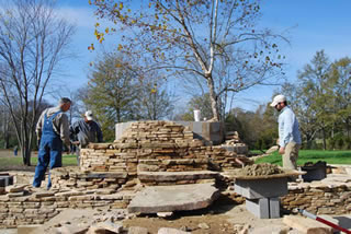
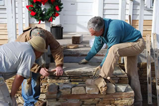
The Margaret Woodruff Library was moved to the Alexandria Park in 2010. The Calhoun County Commission, with District 4 Commissioner - JD Hess spearheading, is in the process of restoring the Woodruff Library to its former glory. The porch was rebuilt and stone steps were added in the Fall of 2010/Spring 2011. Images of the Woodruff Library as seen in 2010 and 2011 are provided below.
 |
 |
Link to todays Public Library of Anniston-Calhoun County
Top
TALLASEEHATCHEE, BATTLE OF
This was the first of the battles of Gen. Andrew Jackson’s army in his campaign against the Indians in the Creek Indian War of 1813-14. It was fought November 3, 1813, between the hostile Creek Indians collected in the town of Tallaseehatchee, and the forces of Gen. Jackson, under the immediate command of Gen. John Coffee. Gen. Jackson was moving his army with difficulty, owing to much needed supplies. Gen. Coffee had destroyed Black Warrior’s Town; and Col. Dyer had burned the town of Littafuchee. The army now had reached Ten Islands on the Coosa River, and Gen. Jackson began planning the erection of Fort Strother. Gen. Coffee was directed to advance on Tallaseehatchee with 920 men. He was accompanied by Richard Brown and a company of Creeks and Cherokees. The town was situated near the head of the creek of that name, about three miles southwest of Jacksonville. It had about 100 families, and a fighting force of 120 warriors, had only recently been increased by 300 warriors, brought together from the towns below, making an Indian force of 420 fighting men. Gen. Coffee surrounded the town about sunrise of November 3. The engagement was swift and bloody. Not an Indian asked to be spared. There is some discrepancy in the accounts of those engaged, but the Indian killed were 186 warriors who were counted, and 18 Indian women. A number were never counted. Some escaped, and fled toward Oakfushee. Gen. Coffee’s losses were five killed and 41 wounded. Eighty-four women and children, and fourteen hopelessly crippled warriors were taken prisoners. The prisoners were sent to Huntsville.
On the same day, Gen. Coffee returned to headquarters.
Of their arms and equipment in this battle, Brewer says-“A noticeable circumstance in connection with this battle is that the Indians were all armed with a bow and quiver of arrows, besides guns, which showed that they had taken to heart the advice of Tecumseh to throw aside the arts they had learned from the whites, and return to their primitive customs.
Buell says, p. 304: “An interesting feature of this encounter was the fact that it was Coffee’s first battle. In his conduct of it, however, he exhibited skill and precision worthy a veteran of many fields. Coffee was an instinctive soldier, an intuitive general. Long after when his native capacity had been developed in many hard-fought encounters, including the battle of the 23d below New Orleans, Gen. Jackson said of him: ‘John Coffee is a consummate commander. He was born so. But he is so modest that he doesn’t know it.’ “
On the death of Gen. Coffee in 1834, Gov. William Carroll of Tennessee said of him in a funeral eulogy: “In view of all the circumstances, I had rather have been the hero of Tallaseehatchee than of the Horseshoe Bend. I had almost said New Orleans itself! It was the first battle of the Creek campaign; the first battle fought by any troops under Andrew Jackson’s command. Upon its issue depended in great measure the morale of our troops, their confidence in their leaders and the buoyancy of spirit that would nerve them to endure the indescribable fatigues and privations to which they were subjected.”
Buell, p. 305.
REFERENCES. ---- Pickett, History of Alabama (Owen’s ed., 1900), p. 552; Brewer, Alabama (1872), p. 152; Parton, Life of Jackson (1861), vol. 1, pp. 436-440; Buell, History of Andrew Jackson (1904), vol. 1, pp. 302-305; Eaton, Life of Jackson (1824), pp. 53-55; (Eaton), Memoirs of Andrew Jackson (1848), pp. 48-49; Jenkins, Life of Jackson (1852), pp. 65-67; Frost, Pictorial Life of Jackson (1847), pp. 132-137; Colyar, Life and Times of Jackson (1904), vol. 1, pp. 127-128.
Top
History
of Alabama and
Dictionary of Alabama Biography
By:
Thomas McAdory Owen, LL.D.
Lawyer, Founder and Director Alabama State Department of Archives
and History, and author of numerous historical and bibliographical publications
Chicago
The S.J. Clarke Publishing Company 1921
Top
 Home
Home